Galleries

  • Comedy Central, Facebook and SAS

    So how small is this world? How big is SAS’s reach?

    Well I recently found out, and thought I would share.

    Back on Saturday, October 30th, there was a little gathering in Washington DC, hosted by a couple of comedians from Comedy Central.

    I was unable to go, so i watched it live on TV, and online with the Facebook crowd, exchanging thoughts about what we were witnessing.

    That unto itself, was very eye-opening!

    Monitoring the main conversation thread, I happen to notice that “Dana Culleney” was beginning to respond to my comments directly, and we began to “chat”, and by the end of the show, we had connected as “Friends” on Facebook.

    Since that day, we have exchanged and commented on a few things, but today that changed.

    About 2pm this afternoon, I posted on Facebook, that “Dead Poets Society” was about to start on HBO.

    After watching the movie, and several hours later, I checked Facebook, and saw this comment:

    Dana Culleney – My husband went to school at that school– it is actually St. Andrew School in Delaware… He still has the school tie… 🙂

    from there, it continued…

    Andrew Seymour – Are you serious? What year? I’m ’82!
    Dana Culleney – Class of ’59– he’s an old dude… 🙂 His father also taught there…
    Andrew Seymour – Does he remember the Quillin brothers?
    Dana Culleney – Stu says ‘yeah, I remember JD.’ Stu’s dad George was in the first SAS graduating class, class of ’34. Small world, eh?!
    Jeff Quillin – Hello, my name is Jeff Quillin, JD is my father and Michael is my uncle.
    Dana Culleney – @Jeff– Stu says ‘hello’ to all the Quillins! We’re over here near Seattle…
    Dana Culleney – @Jeff– Stu says, “It was long ago and far away.” He says your dad was a burly guy with short hair, a football player… 🙂
    Jeff Quillin – Stu, that is right my dad played football, he also wrestled and rowed crew. Dad was very into sports. He also was on the swim team.
    Andrew Seymour – ?@Jeff – Thanks for jumping in! @Dana – Mike senior’s Boys (Mike Jr and David) were in my class, and Mike Jr. was my roommate Senior year… I also worked for both JD and Mike (Sr.) the summer out of SAS, and that is how I got to know Jeff! — Tis a VERY small world!

    and if this were not enough, I got an eMail via the SAS website:

    Andy,
    Guess you and the spouse were chatting on face book. Small world.. I was in the class of ’59. The only quinlin that I knew was JD (’56). My dad, George W. Culleney was in the first graduating class in ’34. i was the first son of an alumnus to go there. We also lived there in 1944-1946, my dad taught english, latin and religion. i have many fond memories of the plac, both living there as a kid and going back to school there. have not been back since 1980. Traveled a lot for the navy (submarine service) and ended up here in Wa State in 1982.Worked for Johnson Controls for 3 yrs and Retired for good in ’92. Just leading the good life now.
    stu

    So how is that for showing the power of the internet to bring folks together!

    Xtras!

    If you happen to be on Facebook, you might be able to read the original thread!

    or if you wish to read the original thread that started this all off from October 30th…

    Note – Dana and I openly tried to start a “World Record” for the “Longest Thread”, but later we learned that the record is over 27,000+ entries! (Ours only got up to 2,200+ entries)

    [contentblock id=1]

  • Glen Hope Covered Bridge (1889)

    Glen Hope Covered Bridge (1889)

    Hickory Hill, Chester Count [38-15-02]

    Finally, it seems that my project to photograph the Covered Bridges of Chester County is done!

    It was a wonderful trip down to the “Southern Most” Covered Bridge in Pennsylvania.

    I approached the bridge from the North side, and immediately knew I wanted to capture the windy road heading into Maryland.

    Glen Hope Covered Bridge (1889) - Looking South
    Glen Hope Covered Bridge (1889) – Looking South

    Driving through the bridge, I parked on the small hill on the South side, and got out of the car.

    While unpacking my gear and surveying Glen Hill, I really had to question myself on the location!

    I thought I was back at Linton Stevens CB!

    I did check the GPS, just to make sure…

    I missed this bridge the last time I was down here in September by ‘fat fingering’ the GPS coordinates and driving into a townhouse area without any creeks, streams or rivers!

    Waking into the bridge, I looked for the plaque, which is located on the Northern side of the bridge.

    Glen Hope Covered Bridge (1889) - Sign
    Glen Hope Covered Bridge (1889) – Sign

    While taking my images of the plaque, a truck pulled up to the Southern entrance, and I signaled it go continue.

    As the man passed me, he stopped, and we began to talk, and after a minute or two, he pulled over, and we began to talk more.

    He introduced himself as Jamie Crouse of Crouse Auto Body in Elkton MD, and had lived in the area all his life.

    As we walked and talked around the bridge, he keep telling me more about its history, such as the over weight truck being stuck inside the bridge during the 1960s.

    Jamie also pointed out the char marks from the arson fire that destroyed the bridge in 1987.

    Burn marks on floor - Glen Hope Covered Bridge (1889)
    Burn marks on floor – Glen Hope Covered Bridge (1889)

    Jamie continued to explain that a great of effort was made to recover as much of the original wood as possible for the rebuilding, which included Bongossi wood from Africa.

    If you look closely at the floor in this picture, you will see large indentations, which were caused by the burning bails of hay and gasoline used to start the fire.

    Some of the vertical posts still show charring from the fire.

    He continued to say, that the two men responsible for the bridge fire are still in jail, and had also been linked to other arson attacks in the area.

    On a more humorous side, he recalled that during his teenage years, two local girls visited Glenn Hope and other local covered bridges of the area, and carved “Boobless Wonder Strikes Again” on the down-creek side and “Woogie” on the up-creek side of the trusses.

    We chatted a little more, and thanked him for the background info, and then he was off.

    So now, where do I start my images?

    The lighting was bouncing all over the place!

    There was a stormy cold front passing over the area.

    Short bursts of direct sun light, followed by various types of clouds, dark ones with rain and white fluffy ones.

    Exposure nightmares!

    But since I was doing HDR images any way, it really was not an issue.

    Glen Hope Covered Bridge (1889) - Looking South
    Glen Hope Covered Bridge (1889) – Looking South

    In this image, you can see the Sun light popping in some areas, but not others.

    HDR and ‘Mother Nature’ work wonders some times!

    Underneath Glen Hope Covered Bridge (1889) - Looking South
    Underneath Glen Hope Covered Bridge (1889) – Looking South

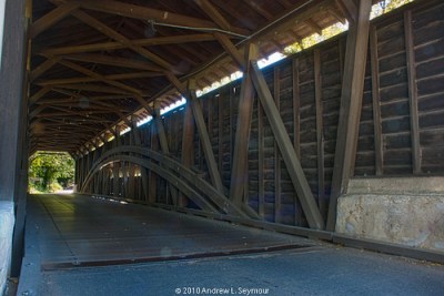
    What I find most striking in this image, this the different layout of the support beams.

    This was the first time that I saw the short ‘horizontal’ support beams instead of the long full-length ‘vertical’ beams of the other bridges, and certainly makes for a different visual capture!

    I moved West up the Little Elk creek, and was able to capture this image looking East.

    Looking East (Down Creek) - Glen Hope Covered Bridge (1889)
    Looking East (Down Creek) – Glen Hope Covered Bridge (1889)

    Featured Image and Photographer (November 2010) – Pennsylvania Covered Bridges

    I did move further up the creek and managed to rip my Domke jacket… My first rip in the 25+ years I’ve owned the vest!

    Bummer… Not a bad rip, but…

    I went up about another hundred feet or so, and took some more images of the rocks surrounded by flowing water.

    I still need to process those, and post them in another entry.

    [contentblock id=1]

    Updates

    10/25/2010 – Finally posted the HDR images to PhotoShelter, Flickr, RedBubble and Panoramio accounts. Also updated the Google Maps.

    10/18/2012 – Notes from a talk given at the Citadel Credit Union about the Covered Bridges of the Oxford area.

    After my presentation, I got to chat with several folks about the bridges, and during one conversation, I was introduced to Joe Chamberlain, who was tasked with removing and repairing the bridge after the cement truck damaged the bridge in 1968.

    He not only confirmed the story, but went on to tell me, that the truck had started over the bridge, got about halfway, when the rear of the truck fell through the decking. He also questimated that there were about  8 yards of cement in the truck, at +/- 4400 pounds/yard, or 17.6 tons on a maybe 10 ton limit bridge!

    Mr. Chamberlain went on to tell me, that the top of the cement truck was still above the deck level, and that he and his crew had to dig into the creek bed to lower the truck enough for them to get it out.

    [contentblock id=4]

  • Knox-Valley Forge Covered Bridge (1865)

    Knox – Valley Forge Covered Bridge (1865)

    Valley Forge, Chester County [38-15-15]

    It still just amazes me.

    Growing up in the area, I had been by and through this covered bridge countless times.

    In my teenage years, it was a ritual to meet at the National Memorial Arch in the middle of Valley Forge National Park after the Prom, hang out, and maybe watch the sun rise. (At least that was the stated goal…)

    With that in mind, why was this bridge so late in my project?

    Don’t know, but I FINALLY got to it!

    But when I first got there, my shot looked like it was in jeopardy because there was a repair crew looking over the bridge.

    So I drove through the bridge from the Yellow Springs Road side, and turned left on Rt. 252.

    I was headed toward the Arch. I had stopped by with Madison on July 30th, but was not happy with what I had gotten that day.

    What was also adding to the day, was the weather!

    There was a front coming through the area, with a great range of dark and light clouds.

    I drove around, stopped a couple of places, took some pictures, and finally headed back to the bridge.

    When I got there, I was happy to see the Repair Crew had gone, and there no cautionary signs, so I drove back through the bridge on Yellow Springs, and park in the little lot on the right.

    I gathered my gear, and started to walk back to the bridge, crossed the road, and hopped over the guard rails to setup for my first shot.

    Knox-Valley Forge Covered Bridge (Exterior Long View) hdr 01
    Knox-Valley Forge Covered Bridge (Exterior Long View) hdr 01

    From here, I moved down the embankment toward the creek, and what I really found striking, was all the flatted tall grass leading to the creek. Tropical Storm Nicole had moved through less then a week before.

    It was a little unnerving to see clumps of grass in the tree limbs at eye level…

    I got to the creek, and tried to find a good water shot, and captured this:

    Knox-Valley Forge Covered Bridge (Down Creek) hdr 02
    Knox-Valley Forge Covered Bridge (Down Creek) hdr 02

    I then headed down the creek, and setup for this shot:

    Knox-Valley Forge Covered Bridge (Underneath) hdr 03
    Knox-Valley Forge Covered Bridge (Underneath) hdr 03

    Pivoting to my left, I headed back up the embankment, and setup for this shot:

    Knox-Valley Forge Covered Bridge (East Entrance) hdr 05
    Knox-Valley Forge Covered Bridge (East Entrance) hdr 05

    This shoot, actually took about ten minutes to capture because of all the traffic coming from three different directions, and with the sun popping in and out… It was allot if fun!

    I walked through the bridge, and setup and captured this.

    Knox-Valley Forge Covered Bridge (East Entrance) hdr 04
    Knox-Valley Forge Covered Bridge (East Entrance) hdr 04

    Again, this image took some time, and in both cases, I was helping to direct traffic.

    From here, I jumped over the guard rail on the left, and captured this:

    Knox-Valley Forge Covered Bridge (Long Low Angle) hdr 06
    Knox-Valley Forge Covered Bridge (Long Low Angle) hdr 06

    If you look carefully, you can begin to see the flatted tall grass on the left, but it does not approach what is just 10-15 feet further left!

    Again, I climbed back up the embankment, crossed over the road, over another guard rail, and down the right side for an up creek view:

    Knox-Valley Forge Covered Bridge (Up Creek) hdr 07
    Knox-Valley Forge Covered Bridge (Up Creek) hdr 07

    From here I headed back to the car.

    Another Chester County Covered Bridge captured!

    [contentblock id=1]

    Tech Talk

    Updates

    [contentblock id=4]

  • Aftermath of Tropical Storm Nicole at Hibernia Park

    Wow it has RAINED!

    Just when you thought it was ending, another wave of rain would hit!

    It was doing this well into the late night and early morning for Friday, October 1st.

    This article from CBS news, “Storm Drenches East Coast, Kills 6 People“, sums up the storm.

    When we finally got up to start the new day, we were greeted with a phone message announcing that the Downingtown area Schools were to have a (2) hour Opening Delay, and the local television news reports were showing segments on Road Closures and Flooding Damage in the surrounding areas.

    Needless to say, traffic was BAD!

    By 11am, I had Madison on the bus and off to school, and Logan dropped off at Day Care.

    I was on my own!

    Now to my Daily “Online Check-In” to catch-up…

    On the “Chester County, PA” Flickr group, I noticed Brian Cox’s photo that he had taken at Hibernia Park, which gave me the idea.

    Fungi DOF by Brian Cox
    Fungi DOF by Brian Cox

    So I fired up Goggle Earth and Maps, and plotted my course into my GPS, and off I went…

    I had NOT been to Hibernia Park since the “Animal Planet Expo” event back on August 18th, 2007!

    I got there and tried to find a Trail Map, but was thwarted because there did not seem to be folks in the Offices, even though there were cars around. (When I got home, I was able to find a PDF Trail map)

    Oh well… on with my adventure!

    After watching some other cars drive by, I drove down a dirt road toward the “Old Dam” area, parked, and gathered my gear…

    Shooting Vest, Lens, extra Memory cards, Tripod, etc…

    I was off!

    What struck me the moment I turned off the car, was the loud sound of water rushing!

    Just by the loud sound, you could tell there had been some rain lately!

    I looked around the “Old Dam” ruins, and saw some water, but nothing really worth photographing, and started down the “Forge Trail”, toward that sound.

    As I got to the first opening on the trail, this is what I saw:

    Hibernia Park (10/1/2010) - 038
    Hibernia Park (10/1/2010) – 038

    Notice the the line of leaves on the right side of the image, to get an idea of how far up on land, the flood line is!

    Walking a little further down the trail, and turning around, I got this the view, looking back up the creek:

    Hibernia Park (10/1/2010) - 060
    Hibernia Park (10/1/2010) – 060

    Again, notice how far up the leaves are on the left side!

    And from this picture, you can CLEARLY see how high the water is from all the rain!

    Hibernia Park (10/1/2010) - 059
    Hibernia Park (10/1/2010) – 059

    I raised the ISO to 1600, and was able to capture these images, trying to illustrate the movement of the water as it barreled down the creek.

    Hibernia Park (10/1/2010) - 207
    Hibernia Park (10/1/2010) – 207
    Hibernia Park (10/1/2010) - 146
    Hibernia Park (10/1/2010) – 146

    You have to LOVE the ability to change ISO in mid “film”!

    One funny moment during this shoot.

    I was setting up my tripod to take a picture, and felt something hit my foot.

    When I looked down, I saw several scared fresh water cray fish jumping around, and then they were off into the creek!

    “Someone” was not happy I was there!

    Hibernia Park (10/1/2010) - 041
    Hibernia Park (10/1/2010) – 041

    This actually happen twice!

    On my trip down and then back up!

    Hibernia Park (10/1/2010) - 283
    Hibernia Park (10/1/2010) – 283

    I continued my walk down creek, past the little pond in the “Lower Damn” area, following Lions Head Drive.

    About midway between “Cottage #3” and “Cottage #2”, there is a little hill, that has a barbecue stand and a picnic table, and from the top of the hill, I was able to get this view point, and take this image:

    Hibernia Park (10/1/2010) - 067
    Hibernia Park (10/1/2010) – 067

    I then moved to in front of the tree to capture, these:

    Hibernia Park (10/1/2010) - 086
    Hibernia Park (10/1/2010) – 086
    Hibernia Park (10/1/2010) - 163
    Hibernia Park (10/1/2010) – 163

    My last capture before “Cottage #2”, was this tranquil little image:

    Hibernia Park (10/1/2010) - 225
    Hibernia Park (10/1/2010) – 225

    Looking at my watch, I started back to the “Old Dam” parking lot, and was able to take a few moments to capture these images:

    Hibernia Park (10/1/2010) - 291
    Hibernia Park (10/1/2010) – 291

    and finally…

    Hibernia Park (10/1/2010) - 315
    Hibernia Park (10/1/2010) – 315

    As you can see, there was allot of “action” on the river!

    When I got to the Parking lot, there was another gentleman just getting ready to begin his adventure in photographing the creek!

    Update – 5 Oct 10 – Turns out, the gentleman I met in the Parking lot was Anthony Leach, a fellow Flickr.com member, and he shared with me, his images from Hibernia Park via Photostream! Check them out!

    I got home with about 15 minutes to spare before Madison got off the bus.

    Yeah!

    As she did her home work, I was able to begin processing the 318 images that I took.

    Again, you have to LOVE the Digital Age!

    Update – 4 Oct 10 – Since originally taking these images, I have managed to publish two (2) different galleries of digital pictures related to this adventure, and I invite you to take a take a look!

    If you have any questions or comments, please feel free to contact me!

    Thanks for taking the time to read my Blog entry!

    Come back soon to see what other adventures I have under taking!

    [contentblock id=1]

  • Kennedy Covered Bridge (1856)

    Kimberton – Phoenixville, Chester County [38-15-13]

    The temperature was warm, but not to bad, and the skies were a deep blue with a few puffy white clouds.

    It was another beautiful day in Chester County.

    I started today’s adventure near the intersection of Route 100 and Route 113.

    From there I took Pike Springs Road North (Rt. 113) towards Phoenixville, and was able to find Hares Hill Road on my left.

    Turn on to Hares Hill Road, I immediately began to see signs that indicated that there was a bridge out in front of me.

    My heart began to sink, thinking that this was going to be a wasted trip.

    I ventured forth, continuing to see bridge close signs, and finally made it to Mill Lane.

    Turning down Mill Lane, which is a small bumpy unpaved back-road, I reached the end , and was delighted to see a small little parking area.

    Once I was parked, I noticed that the Closed Bridge signs had disappeared.

    I gathered my gear, and headed down West Seven Stars Rd. towards the bridge, and was very happy to see that there was no construction visible anywhere!

    At the entrance to the bridge, I stopped and began to assess the traffic situation.

    I could see the bridge sign, just inside, and knew that I was going to have to do my dance with the oncoming cars and trucks.

    Kennedy Covered Bridge 001 (Sign)
    Kennedy Covered Bridge 001 (Sign)

    With some quick timing, I was able to capture some hand-held bridge images, shot at ISO 1600.

    On the sign, one can read, that the bridge had been destroyed by fire in 1986, but was rehabilitated a year later.

    From there I moved back outside and to the base wall of the bridge and began to set up my tripod for my first exterior images of the entrance.

    I knew this was going to take a long time, because the traffic seem to be increasing.

    As I sat there, waiting for the cars, it was interesting to note how people responded to me and my camera.

    Some folks, just wanted to make sure they didn’t hit you and continued along very quickly. Others would smile and wave and occasionally you would get a beep of the horn as a sign of encouragement.

    With the way the sun was hitting the bridge, I decided to walk through, and shoot back for my long interior capture, but in doing so, I had to set up my camera just at the edge of the traffic lane.

    During my captures, I played a policeman with the ongoing traffic.

    This was by far the most time-consuming image and nerve-racking of the day so far.

    Kennedy Covered Bridge hdr 02 (Long Intervior View)
    Kennedy Covered Bridge hdr 02 (Long Interior View)

    I got my captures and begin to look for my next shot.

    Seeing that there were no easy ways to get under the bridge from the school side, I crossed back over, and down the opposite side I had shot from earlier.

    This was nice because there was a little grass area where I could easily set up my low angle view of the bridge.

    From here I moved upstream and look for an easy entrance into the water.

    I found a spot, and started in, finally finding a spot on the far side of the Creek.

    This was going to be another timings shot.

    As I was setting up, I noticed that the school was having the lawns cut and large red mower kept on moving in and out of the shot, all the long kicking up dust clouds.

    Kennedy Covered Bridge hdr 04 (Long Exterior View 01)
    Kennedy Covered Bridge hdr 04 (Long Exterior View 01)

    From there, I moved back down the Creek, crossing over the middle again, and towards the underside of the bridge.

    Climbing over some rocks and up into the concrete area of the undercarriage, I was able to see that the underside for the first time.

    The bridge had a light tan paint which was going to help to illuminate the support structure, and there was a nice contrast between the tan iron beams and the dark wood of the bridge itself, but I had to wait as red lawnmower continued to move back and forth off to the right.

    Kennedy Covered Bridge hdr 05 (Underneath)
    Kennedy Covered Bridge hdr 05 (Underneath)

    From the middle of the undercarriage I continued to my right and up the side of the bridge.

    As I scrambled up, I looked back and saw this long low view of the bridge.

    Kennedy Covered Bridge (Long Side-view)
    Kennedy Covered Bridge (Long Side-view)

    This was my shot of the day.

    But again I had to wait for Mr. Red lawnmower and the dust clouds…

    Finally finished with the shot, I headed back to where I had started about an hour ago.

    I started to head back to my car, got there, and decided to walk up the Creek a little bit more looking for another long view shot.

    Heading back to the Creek, I found another easy entrance to the water and searched around for an appropriate view.

    Finding one, I was able to capture this final image of the Kennedy covered bridge.

    Kennedy Covered Bridge hdr 08 (Long Exterior View 02)
    Kennedy Covered Bridge hdr 08 (Long Exterior View 02)

    Tech Notes

    During my processing of my images, especially HDR 07, I ran into a number of issues with ghosting and color aberrations.

    Initially I posted to Flickr my first attempt of HDR 007, but after being too frustrated with what I was looking at, I re-released the image after spending some more time with it, and that is what is posted her. If you wish to see the original, it can be found on my Flickr PhotoStream.

    – Andrew
    § § § § §
    [adrotate banner=”1″]
    § § § § §

    Cross Links